Monday, December 21, 2009

Axios uDig Extensions 1.2.3 for uDig 1.1

Recently, we have published the release 1.2.3. It includes fixes for the Split and Parallel tools and cap styles for the Buffer spatial operations.

This product is available in the udig update site and www.axios.es download page.


Wednesday, December 2, 2009

Is coverage styling finally coming to uDig?

Finally we have been able to get paid work on raster styling. Taking the JGrass raster styling gui as a starting point, we have been able to give the coverage styling a go.

To read the whole of it, see here.


Thursday, November 12, 2009

How to add a new spatial operation

Hello everyone, we have published a tutorial which shows how to extend the spatial operations framework with new spatial operations.

We expect this document to be interesting for those developers who want to include existent spatial operations or develop a new spatial operation for uDig, taking advantage of the spatial operations framework.

In this tutorial we develop the spatial operation Centroid. The screenshot shows the user interface idea. In the presented example the centroid operation has created a new layer called Centroid_1 using as source layer the countries layer.

To download visit our web site www.axios.es, "Tutorials and Documents".

cheers

Friday, November 6, 2009

AXIOS UDIG EXTENSIONS 1.2.2

This release, available for uDig 1.1.x, includes improvements
and bug fixes in the Parallel Tool.

Also, you could have a look in the development branch. The axios suit 1.3.0-m2 was tested with uDig 1.2 M6.

To download this new releases please visit the uDig update-site or our web site www.axios.es download page.

Wednesday, October 7, 2009

New UDIG3D alpha release!!

We are delighted to announce the release of uDIG3D alpha version 0.1 with
support for 3D spherical (WGS84) maps and 3D projected maps. A new 3D Map is
integrated within udig to be managed as a simple map but with the advantage of
3D representation.

It makes use of OSGVirtualPlanets(osgVP) version 2.2.0. osgVP is a library
developed in the Instituto de Automática e Informática Industrial(AI2) of the
Universidad Politécnica de Valencia(UPV).

If you want to test this release you can download a complete uDIG with the
necessary plugins and native libraries from here:

Linux Version:
http://www2.ai2.upv.es/difusion/uDIG/udig-linux-i386-alpha-v0.1.tar.gz

Windows Version:
http://www2.ai2.upv.es/difusion/uDIG/udig-win-i386-alpha-v0.1.zip

Some video demonstrations can be found here:
http://www2.ai2.upv.es/difusion/uDIG/demo-uDig1.swf
http://www2.ai2.upv.es/difusion/uDIG/demo-uDig2.swf

User Guide:
https://svn-gis.ai2.upv.es/svn/gis-projects/udig-extensions/trunk/Documentation/UserGuide.pdf

If you are interested in taking a look at the code the svn access is:

uDIG3D Plugin:
svn co https://svn-gis.ai2.upv.es/svn/gis-projects/udig-extensions/trunk udig3d-trunk

osgVP Plugins:
svn co https://svn-gis.ai2.upv.es/svn/gis-projects/osgvp/trunk/ osgvp-plugins-trunk

osgVP:
svn co https://gvsig.org/svn/osgvp/trunk/ osgvp-trunk


NOTES:
There is some known problems with the persistence of the 3D Maps, so we
apologize for possible issues. If anyone is interested in continuing or support
these developments please contact us.

Tuesday, August 18, 2009

uDig 1.2 M6

The uDig 1.2 "milestone 6" release is available for download.

This release is the result of an amazing week long code sprint held at Hydrologis in Italy supplimented by developers all over the world. A special thanks to the participating organizations: Axios, Camptocamp, Fraunhofer IAIS, HydroloGIS and LISAsoft.

The milestone release features:
  • Better support for TIFF and depending on your platform ECW and MrSID with an update to the imageio-ext library
  • Enhanced vector editing, revamped printing support
  • Upgrade to the latest Eclipse 3.5 (finally we can offer cocoa support on mac!)


Here are some example of some of the enchancements:
  • Import multiple layers into catalog at once
  • Deleting multiple maps only asks for a single confirmation and delete
  • standard paper sizes are now supported when printing!
  • Add rectangles, roundrectangles and ellipse when printing
  • Drag and Drop improvements: drag and drop mixed content in the catalog and map, move several maps at once, multiple services on project at once, handle multiple layers in the layer view
  • Improved workflow: An Open Map action, switch between common map scales
All in all 41 issues have been addressed for this release - for more information check the release notes.

Friday, August 14, 2009

AXIOS UDIG EXTENSIONS 1.2.0

This release, available for uDig 1.1.x, includes new features, improvements and bug fixes. We want to highlight the following ones:


NEW FEATURES

  • Spatial Operation Split splits features from a source layer using a LineString features from a second layer (or reference layer).
  • Spatial Operation Fill creates a new geometry using the reference line and the border of the source polygon as its own border.
IMPROVEMENTS

  • Merge Tool the usability has been improved in several ways.

  • New Split algorithm, it allows add vertex to neighbour geometries. Additionally, it solves many reported problems in the old split tool.

  • Spatial Operation Dissolve allows to select multiple dissolve property.

  • The spatial operation framework was factored to provide an easy way to extend with new operations. Thus the control logic was encapsuled in abstract classes to simplify the creation, associations presenters- commands and event handling .
  • Spatial Operation Extensions Point allows to add new spatial operations in the default set.

To download this new release please visit the uDig update-site or our web site www.axios.es download page.

Finally, we want to thank uDig community for your comments and suggestions to improve this product.


If you want to know more about this project visit the
following page: uDig Axios Community Space - Spatial Operations and Editing Tools

Monday, August 3, 2009

FOSS4G2009 presentations about uDig and friends

The FOSS4G2009 presentations are defined, so here are some uDig related presentation that you might be interested to attend:

Here is what the HydroloGIS team came up with:
  • JGrass, present and future
  • Anatomy of a digital field mapping with BeeGIS
  • JGrass-uDigs's sense for climate change
A very interesting live demosnstration comes from Potsdam, as suggested by Matthias Lendholt:
  • Live Demonstration of DEWS (that will show a Tsunami Early Warning System using uDig and GeoTools. If the network connectivity works properly they will show a life scenario instead of a powerpoint presentation)


Are there others around? Please send us an email if you are presenting something related to uDig & friends.

Wednesday, July 22, 2009

IRC meeting about post code sprint release

The meeting agenda was as follows:
1) jre's and startup scripts
2) to style or not to style
3) where is my printer
4) editing bugs ade

The good news is a release being organized for Friday.

Tuesday, July 21, 2009

Code Grind 09 wrap up

The world-wide code sprint/grind has now wrapped up and with very good results. uDig trunk is very functional with an incredible number of bugs and usability issues addressed. Many (although not all) have been listed in other blog postings. We will be combing through the logs and getting a complete list of the issues addressed very soon.

There is only one more task to complete the sprint: make a new Milestone release.

The new release will be trimmed down to the plug-ins that we think work very well and all other plug-ins will be moved to a unstable feature that will be avalaible from the update site (once the final, non-milestone, release is made).

The unstable feature will also be available to developers in the SDK (that is the current plan but is up for debate).

We hope to finish up the release this week and get it on-line.

Good work to all the developers who helped out and the organizations who sponsered them:

Thursday, July 16, 2009

uDig Code Grind Day 4 Australia

An interesting day ... John Hudson returns with a partner in crime by name of Jim Groffen and proceed to keep pace verifying all the bugs being fixed. They also identified the instructions for setting up a development environment as in need of fixing (due to the recent arrival of Eclispe 3.5).

Mark started hooking his user interface up to the StyleBlackBoard (and then want off on the town all dressed up - perhaps he had a date? Ugo Taddei is not the only good looking guy around here).

Jody stayed up till oh dark early with the following (admittedly cool) screen snaps emerging. The first one is command completion with the entire function list avaialble as you type. And it is generated on the fly so it is always current!


Next one is also interesting - field decorators that can provide feedback (warnings; errors; if the field is erquired etc...).


Yes the warning tool tip on the decorator is a really horrible message from the Extrended Common Query Language Parser - I am going to see if we can get row,col information out so we can highlight where the problem is exactly and save the message as a "more details" kind of thing.

Wednesday, July 15, 2009

uDig Code Grind 2009 Europe Day 3

Day 3 of the code sprint has come and gone and Day 4 has now begun. Another fantastic day of work.

Here's a quick summary:

Andrea Antonello (HydroloGIS)
  • Compiled ImageIO ext for Mr.Sid and Geotiff on Mac
  • Reviewed printing framework
  • Added z-ordering actions for the Page layout
Jesse Eichar (Camptocamp)
  • Some low level work to make more of uDig use the ID objects to identify Services and GeoResources
  • Refactored Raster plugins to share more code
  • Added type of raster to the titles of raster layers. This is required because multiple plugins can handle geotiff (for example) and there needs to be a way to distinguish between them.
  • Windows still had a problem persisting services in the catalog. This was fixed.
  • Improved displayed title for rasters in layers view
Silvia Franceschi (HydroloGIS)
  • Saving our life with testing
Mauricio and Aritz (Axios)
  • Set up environment for Aritz
  • Finished fixing a very challenging bug with hole tool

The uDig Code Grind Team

You might be asking yourself who is on this sprint. Here we go with nice pics, so at the next Foss4g conference you can recognize them and ask them to solve your problems for free. :)

In random order:

1) Lisasoft Adelaide team: Jim Groffen and John Hudson


2) Lisasoft Sydney: Mark Leslie


3) ...and Jody Garnett


4) Camp2camp and HydroloGIS Bolzano based team: Jesse Eicher and Andrea Antonello


5) HydroloGIS Bolzano: Silvia Franceschi


6) Axios Spain: Mauricio Pazos and Aritz Dávila


7) Fraunhofer-Institut Germany: Ugo Taddei (for the ladies we should mention he is Brazilian and has Italian blood)


All around the world!!!

Tuesday, July 14, 2009

uDig code grind day 2

Another very long day of bug fixing has just wrapped up. The day progressed more or less the same as yesterday.

Andrea Antonello (HydroloGIS)
  • Andrea has gotten the image-io-ext working on linux 32 and 64 and windows.
  • Andrea has Mr Sid and geotiff in image-io-ext compiling on Macosx and is now in a grand battle with ECW to get it to compile.
Jesse Eichar (Camptocamp)
  • I spent another day fixing bugs. Some of which include:
  • Updated features and files so that we can export uDig on Eclipse 3.5
  • Fixed a bug when selecting several features using shift select
  • An important editing bug related to the selection
  • Fixed an issue when a new layer is created that has the same name as an existing layer
  • Fix an exception that is thrown when writing wgs84 into the CRS Selection dialog
  • Improved performance (but worse for memory) for JPEG and other simple world+image formats. Hopefully more to come.
  • Working on problem importing a tiff that is both a geotiff and a world+image
Sylvia (HydroloGIS)
  • Lots of testing
  • Writing a workflow as an end user
  • Bug fix verification
Mauricio (Axios)
  • He is in Spain right now so I don't have the details of his work but I am aware that he has been doing work on the more advanced features of the edit tools. He is working on fixing bugs with the hole cutter I believe.

uDig Bug Crunch Day 3 Australia

Bug crunching is in full swing today with almost all the bugs to be marked as FIXED on the Code Sprint Road Map verified and closed.

Moving onto the "to be verified" list, I started to see a trend for "Catalog Improvements" issues. After a short discussion on the uDig IRC channel, Jody and I came to the conclusion we should make a single Feature Request and close all the other issues, check it out here. Looks like this has been something wanted for quite sometime, I closed five separate feature requests.

For the interested, Jody as been working on a new Catalog View Proposal which outlines a improvements, check it out here, its pretty cool!

uDig Code Grind Day 2 Australia

Today we are branching out across Australia with LSIAsoft developers from Sydney and Adelaide.

First up is John Hudson, drawing on earlier motivation, has focused on chewing the bugs listed on the Road Map and verifying and/or closing bugs.

Back in Sydney Mark has started putting together the new Point Symbolizer page (see below).

Jody was mostly decorative and has been working on a reuseable ExpressionViewer to use for each of the fields above. He promisses to be useful tomorrow.

Monday, July 13, 2009

uDig Code Grind 2009 Europe Day 1

An exciting day 1 is wrapping up here in Europe. The fine coalition (Axios, Camptocamp, HydroloGIS) have been hard at work knocking down bugs. A quick list of the tasks we have been working on for today:

Jesse Eichar(Camptocamp) - Many miscellaneous workflow bugs:
  • Drag and drop bugs
  • Import data bugs
  • Selection bugs
  • Map and Catalog persistence bugs
Andrea(HydroloGIS) - Image IO
  • Working on getting the GDAL/ImageIO plugins working on Linux 32/64 and windows
Mauricio (and co) (Axios) - Editing Bugs
  • Hole tool bug
As a team we are focusing on addressing as many bugs that affect the core functionality of uDig.

See you tomorrow!


Have a look at the Italian sprint headquarter:


Can you guess on how many systems udig is tested?

Sunday, July 12, 2009

Code Grind Sprint Day 1 Kickoff

It is our please to kick off the code grind sprint. We will add to this news post over the course of the day as each team around the world starts up.

LISAsoft Team


Myles is starting in on the tutorials and was very happy with the result.

Mark and Jody are going to be going over the Style Editor (design notes here).

Update: We reviewed the three style extension points; StyleEditorPage (very good but specific to SLD); StyleConfigurator (general purpose the content will go in the StyleEditor using an adapter or be present in the Style view); and the StyleEditorPart (while we can see implementations I am not sure where they are used from?).

We decided to go with StyleEditorPage and expect to add a few methods as time goes on this week. Here is our initially empty "Point" page.

Eclispe 3.5


For those joining the hands on experience here are some instructions for getting your Eclipse 3.5 game on:

  1. Download Galileo " Eclipse for RCP/Plug-in Developers" for and unzip

  2. Fire it up and add EMF SDK and GEF SDK into the mix using the help menu "Install New Software"

  3. Download extras-3.5.0.zip and unzip into your "drop-ins" folder. We are operating with a really reduced set of "extras" this time around since we have had some trouble with the Eclipse 3.5 delta pack.

  4. Proceeed remaining instructions...

RoadMap and Testing


Silvia has done a nice job updating the road map to focus on uDig 1.2 M6 bugs - this will be a large part of the QA focus of the code spint.
For more information please check out Road map; we also would welcome any volunteers to help out with testing this week - there are already a long list of "resolved" issues that need a sanity check before we mark them closed.

Tuesday, June 16, 2009

New Server

Refractions is kindly hooking us up with a new server; there may be some transition pains as the website, mailing list and wiki are moved across.

In order to facilitate the global nature of uDig development Jesse Eichar from our project steering committee is also experimenting with a GIT repository located in Europe. For more information please join the developer list and say hi.

Monday, June 15, 2009

AXIOS UDIG EXTENSIONS 1.2.0-RC01 (Testing)

This release, available for uDig 1.1.x, includes new improvements and bug fixes. We want to highlight the following:

Split Operation. We have fixed the split behaviour to split a geometry properly using complex split line like it's shown in the following figures.


Split Operation. Fixed the split behaviour to split geometries properly when splitting several neighbour features.

– The Spatial Operations framework was refactored to provide an extension point that could be used by other developers to add new operations.

To test this new release please visit the uDig update-site or our web site www.axios.es download page. Here you can find the latest stable release Axios uDig Extensions 1.1.4, as well as the latest under development release Axios uDig Extensions 1.2.0-RC01 for uDig 1.1.x.

If you want to know more about this project visit the
following page: Spatial Operations and Editing Tools

Tuesday, June 2, 2009

uDig Code Grind 2009 coming up!

We are embarking on a week long code sprint from July 13 to 17. The main goals are to focus on the core features and functionality of uDig 1.2 and ensure that they are release ready.

This will be a world-wide event with several members Australia as well as others from Europe and North America. We will maintain a strong presence on IRC but will supplement it with frequent skype calls and video conferences.

Everone is welcome to join. Documentation, testing or coding: all contributions are welcome.

Our many thanks to the sponsers of this sprint:

Axios,
CamptoCamp,
LisaSoft,
Hydrologis.

Friday, May 29, 2009

WireframeSketcher

One of the eclipse plug-ins I ran into recently is really pretty impressive. I have used Viso to do user interface mock-ups before - but there are kind of two problems with this approach:

  • the result looks like a real application; so if you show it to a customer they want to stop talking to you and run the application
  • the Viso templates only provide a Windows XP appearance which is pretty lame these days

It turns out that the Viso templates were "removed" from the latest copy of Viso (along with a bunch of other useful things) and held ransom as part of a Professional Edition.

So I went off to look .... and found something better :-)


WireframeSketcher - http://wireframesketcher.com/

This is an eclipse plug-in, it is beautifully written, and very fast to quickly slam together a ui mock up.

And even better the result looks like a ui mock up; allowing every one to stay focused on the workflow; the trade offs; and how the user interface functions rather than get distracted by the font used or the icons.

Perfect.

Here is an example mock-ups done for the uDig style editor.


Stay tuned (or jump on the mailing list) for styling plans.

I have added a page on WireframeSketcher to the udig list of recommended tools in our wiki.

We keep a list of good design ideas on our wiki; in order to refine the ideas before implementation, this tool should be helpful in those discussions.

Wednesday, May 27, 2009

Google Summer of Code 2009

This is the first week of the Google Summer of Code - an event uDig is once again pleased to take part in. This year we have two fascinating projects:
  • Web Map Tiles for uDig - Tobias Sauerwein is going to go beyond the WMS-C support uDig currently enjoys and branch out to tile server implementations. Check the above link for details.

  • netCDF - Andrea Antonell is tackling one of the most expressive raster formats known. This project should produce both wonderful visuals; and some interesting user interface design challenges.
Check back weekly for updates on both these projects.

Monday, May 25, 2009

uDIg 1.2-M4 Released

Another 1.2 milestone release for your testing pleasure. This release includes lots of fixes for WMS-C support. WMS and WFS support has been heavily tested against the Australian SLIP data services.

This release of uDig can be found in the usual location:
Unstable Downloads

The SLIP portal has been featured on our data wiki page for some time. Once you have signed up you are sent a user name and password which you can enter when connecting to their data services.


I would also like to thank OpenGeo for the excellent WMS-C tile server "sigma". Sigma is listed in the "Web" view of the main uDig application if you would like to try it out.

Here is what the two data services look like together:

Thursday, March 26, 2009

UDIG 1.2-M3 Released

Normally I would tell you what great new thing is in a release - this time I would like to ask you to look at the release notes!  An amazing 60 bugs closed (and 13 more waiting for testers to verify).

This is the result of the "10 minuet code sprint" where the development community got together and fixed as many bugs as they could over the course of a couple of days.

The UDIG 1.2-M3 release is available here:
- http://udig.refractions.net/download/unstable/

Tuesday, March 24, 2009

AXIOS UDIG EXTENSIONS 1.1.2

This release, available for uDig 1.1.1, includes new improvements and bug fixes. We want to highlight the following main improvement:

Split Operation. We have improved the split behavior by allowing the tool to add one or more vertexes to the neighbor geometries (whose boundaries are intersected by the split line) of the one that has been split.

To test this new release please visit the uDig update-site or our web site www.axios.es download page. Here you can find the latest stable release Axios uDig Extensions 1.1.2, as well as the latest under development release Axios uDig Extensions 1.2-M3 for uDig 1.1.1.

If you want to know more about this project visit the following page: Spatial Operations and Editing Tools

We want to thank Rudolf Hochmeister from the Municipal Department of Automated Data Processing, Information and Communications Technologies, Vienna City, for his contribution to improve this project.

Friday, March 20, 2009

udigLite: An OSGi-friendly subset of uDig

Depending on your environment, you may find it hard to integrate other OSGi bundles or Eclipse plug-ins with uDig. My team and I have tried for some time to build a viewer application for a proprietary car navigation database format on top of uDig 1.1 releases or uDig 1.2 trunk snapshots, fighting with version conflicts and class loader issues caused by the "grab all you need" plug-in net.refractions.udig.libs.

The root of these problems is Geotools and its dependency on the META-INF/services mechanism, which requires some trickery to be made compatible with OSGi.

We have now succeeded in creating a minimal subset of uDig and Geotools which solves these conflicts by turning all Geotools and third-party libraries into separate bundles. For technical reasons, we had to work with cloned repositories, which should simply be regarded as a uDig working branch.

More details about udigLite can be found in the uDig wiki. Have a look at my blog to get an idea of what we are using uDig for.

Finally, thanks for all the support from the uDig community so far - we very much hope to join forces to bring the results of this activity back into uDig trunk.

Tuesday, March 10, 2009

TileSync


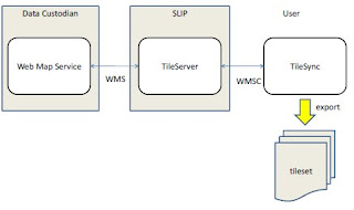
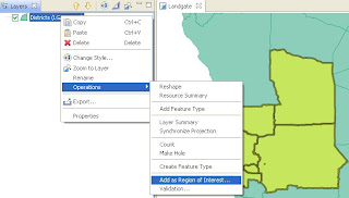
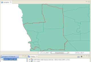
TileSync, based on uDig, developed by LISAsoft in conjunction with Landgate and ExaMin, allows a user to select any feature (Polygon) and add it as a Region Of Interest to a Region Of Interest View. The View allows the User to locally cache a any WMS-C Layer in the Catalog within the bounds of the Region Of Interest. The plugin also allows the local cache to be exported with TAB (MapInfo) header files and a seamless XML file.


Also included is a MapGraphic which outlines the Region of Interest on the Map View when it is selected in the Region of Interest View.


A bundled version is available for download here, and a copy of the plugin can be checked out of the uDig community SVN here.

I have made up some flash videos on usage available online:

Friday, March 6, 2009

The 10 minutes bug code sprint

What is the 10 minutes code sprint?


A code sprint in which bugs and feature requests will be fixed that are supposed to take only 10 minutes to the involved developer (in a perfect world).


Further info at the Osgeo wiki.

Thursday, March 5, 2009

IRC Logs March 6th

[07:06am] jgarnett: morning
[07:07am] jgarnett: emily_g ping? were you able to sort out where layer.refresh() goes?
[07:07am] emily_g: hello jody
[07:07am] emily_g: no
[07:07am] emily_g: I wasn't
[07:07am] emily_g: layer.refresh() doesn't fire any events
[07:09am] jgarnett: um it does something though right?
[07:10am] jgarnett: somehow it adds a bounding box to an area that needs to be repained for a layer
[07:10am] jgarnett: and queues up a RenderJob to handle it right?
[07:11am] emily_g: yes that sounds about right
[07:11am] emily_g: but there are no events there that I can listen for
[07:12am] jgarnett: um from the ui I can listen to the layer state changes; rendering, etc... I think I can listen for layer refresh as well
[07:12am] jgarnett: (I am sorry I am at home on funny mac thing and do not have the source code in front of me)
[07:13am] emily_g: funny mac thing eh? sounds like fun
[07:13am] jgarnett: so if there were no events RenderJob would of been called directly via layer.refresh?
[07:13am] emily_g: LayerImpl.refresh calls getRenderManager.refresh()
[07:14am] emily_g: now that I think somehow calls RenderJob
[07:14am] emily_g: but I guess I need to walk further into the code
[07:14am] emily_g: I kind of stopped there thinking I hit the wall
[07:14am] emily_g: but you have a point; I may need to go further and look at layer state events or render events
[07:15am] emily_g: I have a couple questions about the current udig graph module
[07:15am] jgarnett: sure
[07:15am] emily_g: 1 - it has very few to no comments; this really isn't cool if you are trying to understand what's going on
[07:16am] emily_g: 2 - it looks to me like you can only route on one dataset at a time
[07:16am] jgarnett: (although the news here is that if you need to change how graph works you can - it is not used much yet and has not seen public release)
[07:16am] emily_g: (the waypoints are stored on the map blackboard)
[07:16am] jgarnett: thinking ....
[07:16am] jgarnett: 1. you are correct about the comments; mostly that is because the graph functionality is document well on the geotools wiki
[07:17am] jgarnett: I should go through and add at least class level commens (ie meet the udig requirements for comments)
[07:17am] emily_g: ya; I think that would help
[07:17am] jgarnett: 2. this is something that can be changed I guess
[07:17am] emily_g: I'm not sure we need to change it
[07:17am] jgarnett: it depends on where you store the graph data structure
[07:17am] emily_g: I'm just trying to understand what is happening now
[07:17am] jgarnett: is routing actually making sense on more than one data set?
[07:17am] jgarnett: I could see a public transit one and a car one
[07:18am] emily_g: or trasit; car; walk & bike
[07:18am] emily_g: or maybe you want to test different dataset
[07:18am] jgarnett: but not both at the same time; you would set up what you need and then ask it to generate a route
[07:18am] emily_g: and see how the attributes give you different routes
[07:18am] jgarnett: yeah okay fair enough
[07:18am] emily_g: i'm sorry i'm making up use cases ... I don't actually have that use case ... yet
[07:19am] jgarnett: so the workflow for that package right now places a graph on the map blackboard; we would need it to change and place a graph on a layer blackboard; and make a single renderer to show way points and the route calcualted against that graph.
[07:19am] jgarnett: you guys are using pgRouting; and I am mostly interested in assuring you make use of the catalog api correctly
[07:20am] emily_g: I'm sure we are not
[07:20am] jgarnett: (ie it would be bad form to start doing data access connection stuff at the layer level)
[07:20am] jgarnett: did you get my origional message to Tim?
[07:20am] emily_g: yes I did
[07:20am] emily_g: but I'm still working on understanding it
[07:20am] jgarnett: I tried to think it through ... but I may of missed something. I assume he had gone through Service / Renderer / Style tutorials.
[07:20am] emily_g: You said somewhere that we should just use the postgis connection in the catalog - I don't think we can guarentee this is already a connection in the catalog
[07:21am] emily_g: our client also has some "weird" requirements that they want the connection stuff as a different bundle; so what we do for them will probably be a bit different from what we do for udig
[07:22am] jgarnett: um the requirements are fine
[07:22am] jgarnett: you can add functionality to the udig postgis from a different bundle
[07:22am] jgarnett: backing up to the larger picture
[07:22am] jgarnett: we want to make sure the postgis connection pool is managed stupidly well
[07:23am] jgarnett: and it would be good to share the connection between the postgis datastore and the pgRouting api
[07:23am] jgarnett: is that okay / understandable?
[07:23am] emily_g: yes - you want one connection
[07:23am] emily_g: makes sense to me
[07:24am] jgarnett: well one connection pool
[07:24am] jgarnett: so for your customer do you have access to the udig catalog?
[07:24am] emily_g: aren't connection pools managed by geotools datastores?
[07:25am] jgarnett: (this conversation kind of has two parts; one about how to manage the connection pool and another about how to intergrate with the graph tools)
[07:25am] jgarnett: not really; when you construct a geotools datastore you can hand in a connection pool
[07:25am] jgarnett: (or you can specifiy a bunch of optional parameters and ask it to create you one)
[07:26am] jgarnett: either way will work here; we need to get access to the connection pool for the PostGISserviceImpl
[07:26am] jgarnett: (I think there may already be a resolve target - for ConnectionPool or Connection)
[07:26am] jgarnett: I am not too worried about that ...
[07:26am] jgarnett: mostly about defining an API to access pgRouting; and then making sure you can get the connection pool in behind that api
[07:26am] emily_g: the thing is in the end our client may not want a direct connection to postgis anyways
[07:27am] emily_g: they may want it go to through some middleware connection
[07:27am] jgarnett: Do you have an API for pgRouting yet?
[07:27am] jgarnett: ah right - fair enough.
[07:27am] jgarnett: even more important to make an API then
[07:27am] jgarnett: (and consider spring remoting when implementing the api for your client - in order to reduce the cost of setting up the middleware)
[07:27am] emily_g: yes and no; I'm not really ready to answer that question
[07:27am] jgarnett: okay np
[07:27am] emily_g: i'm still working on it
[07:28am] jgarnett: at somepoint here will be some methods right?
[07:28am] jgarnett: hand in a start and end point and get back a route; or whatever other services pgrouting offers (I have only read about it)
[07:29am] emily_g: yes it is basically that
[07:29am] emily_g: pass in some points & route type and get back geometry
[07:29am] jgarnett: thinking
[07:30am] jgarnett: sorry for the distraction on the postgis front; going through some middleware thing is a bit different
[07:30am] jgarnett: I would probably handle it by defining that API
[07:30am] jgarnett: and sticking that object on the map or layer blackboard
[07:30am] jgarnett: and defining the graph tools against that object (or graph wizard or whatever)
[07:31am] jgarnett: and then I would implement using geotools graph
[07:31am] jgarnett: and implement using the middleware
[07:31am] jgarnett: and if we have call to talk to postgis directly I would go off and play that game.
[07:31am] emily_g: that's sort of what we are doing I think
[07:31am] jgarnett: in some sense that makes defining the api easier; since it comes down to what you need the tools to be able to call.
[07:31am] emily_g: without the geotools graph stuff because that is already handled for us by pg routing
[07:32am] emily_g: the problem I was having was want to do with our pgRouting API implementation; but you are correct - we can put it on the map blackboard
[07:32am] jgarnett: in anycase feel free to manipulate the graph module into that shape; it may even be a helpful move for your project since it would allow you to test prior to the create of the middleware bit
[07:33am] jgarnett: ah right - putting custom components on the map (or layer blackboard) is the way to go.
[07:33am] jgarnett: you may find that you need a bit more lifecucle control;
[07:33am] jgarnett: ie if the layer was deleted you may want to be told about it?
[07:33am] jgarnett: if that is the case we may need to look at making the blackboard a little smarter (ie more into a container)
[07:34am] jgarnett: but no sense causing trouble unless you have the need I figure.
[07:34am] jgarnett: um you did this approach for the birds demo; so I thought it would be fresh in your mind
[07:34am] jgarnett: (still want to write that demo up for others)
[07:34am] emily_g: ya; and I've used it for the mapgraphic rendering problem;
[07:34am] emily_g: just didn't clue into it; too many other things going on
[07:35am] emily_g: i have a meeting shortly and I need to eat so I'm going to run away
[07:35am] emily_g: thanks for the help
[07:35am] emily_g: is there an official irc meeting tommorrow?
[07:35am] jgarnett: okay; I will post these logs; and spend the rest of the meeting timeslot here on sorting jira bugs.
[07:35am] jgarnett: Today is friday for me; and this is the meeting timeslot.
[07:36am] emily_g: okay I'm confused between what day it is
[07:36am] jgarnett: Andrea wanted to go over Jira bugs (in prep for a code sprint) tomorrow
[07:36am] jgarnett: np
[07:36am] jgarnett: that is what weekends are for; to help you organize what day is where (or when?)
[07:36am] jgarnett:
[07:42am] jgarnett: thanks for the chat emily

Sunday, March 1, 2009

FOSS4G 2009: One week extension to Workshops and Tutorial submissions

Sydney, Australia. 2 March 2009.

In response to requests from presenters, the deadline for the FOSS4G 2009 workshop and tutorial abstract submissions has been extended by one week, to Monday 9 March 2009. If you are considering submitting a workshop, please notify your intent by emailing the Workshop/Tutorial coordinator, Mark Leslie m a r k . l e s l i e AT l i s a s o f t . c o m


About FOSS4G

FOSS4G, held 20-23 October 2009 in Sydney, Australia, is the international "gathering of tribes" for open source geospatial communities. The theme for the FOSS4G 2009 conference will be "User Driven". Users and developers are encouraged present their latest projects and software to demonstrate the power of Open Source for system integration through a series of workshop sessions and tutorial presentations. Session participants should expect to see presentations on both geospatial open source and propriety software integration along with pure open source solutions.


Workshops

Workshops are expected to be a hands-on experience with participants following along with the instructor, working directly with the application under discussion. All workshop rooms will be equipped with computers (two students sharing one system) to support this vision. Workshop computers will pre-installed with a basic image containing standard packages running in a Windows XP environment. A projector will be provided for each computer room for use within a workshop. Instructors will need to discuss pre-installation requirements with the Conference Organising Committee if required.

Workshops are expected to require considerable effort to create, with past experience showing that three days of preparation per hour of presentation are required to produce a high quality workshop. Additionally you will be expected to develop material for attendees to take home with them, such as handouts, workbook, CD-ROMs etc. Due to the effort involved in producing and presenting a workshop, instructors will receive a single complementary registration to the conference for delivering a workshop.

All workshop submissions will be considered, but particular interest will be shown in the following topics:

  • Practical Introduction to ____
  • Integrating Open Source
  • Spatial Data Privacy and Security
Tutorials

Tutorial rooms will not be equipped with computers, however presenters may optionally make use of delegate laptops and the FOSS4G LiveDVD.

At least 80% of delegates are expected to be carrying a laptop and FOSS4G LiveDVDs will be given to all delegates.

Preference will be given to hands-on tutorials.

Any hands-on aspects to a tutorial will be the responsibility of the presenter and needs to be described in the tutorial description. Presenters making use of the Live DVD or Climate Change Integration Plugfest (CCIP) will be expected to contribute to testing pre-releases to ensure material and software is properly installed. To discuss your requirements for LiveDVD, please contact the organising committee: http://2009.foss4g.org/contacts/.

All tutorial submissions will be considered, but particular interest will be shown in the following topics:
  • Practical introductions
  • Interoperability
  • Spatial data accuracy
  • Spatial data privacy
  • Spatial data security
  • System implementation
  • Data migration
Submission instructions and templates are available at http://2009.foss4g.org/workshops/and http://2009.foss4g.org/tutorials/.

The deadline for workshop / tutorial submissions is March 9, 2009

Thursday, February 26, 2009

IRC Logs Feb 27th

uDig IRC meeting:

(7:09:51 AM)
jgarnett: morning!
(7:10:00 AM) jgarnett: I am getting better at this (and getting better)
(7:10:10 AM) emily_g: good afternoon :P
(7:10:19 AM) jgarnett: this should be my last week of coming into the office early to attend these things
(7:11:06 AM) jgarnett: (finally ordered internet for my house)
(7:11:19 AM) jgarnett: I am going to send a quick email to the list and see if we can scare up more people
(7:11:21 AM) emily_g: how exciting
(7:11:35 AM) jgarnett: but there is some interesting things going on SoC, FOSS4G workshop deadline etc
(7:12:32 AM) jgarnett: how is your hacking going emily?
(7:13:12 AM) emily_g: good for now I think I'm mostly done what I need to do
(7:13:30 AM) emily_g: I'm still now sure how to deal with udig community module relying on the unsupported geotools module
(7:13:57 AM) emily_g: I've been committing a jar file which I know is a very bad thing :)
(7:14:03 AM) jgarnett: gak!
(7:14:07 AM) jgarnett: well there are two ways
(7:14:50 AM) jgarnett: 1. make the geotools module supported; we really should not be selling our customers less (the supported mechansim exists mostly as a measure of quality). The process work gdavis did is in a similar bind I am afraid
(7:15:12 AM) jgarnett: 2. do not make it supported; and make udig libs suck up the dependency
(7:15:29 AM) jgarnett: Question - is this just a code dependency? Or is does it need to hook into the geotools factory finder thing?
(7:16:14 AM) jgarnett: Finally you could have a refresh.xml script fetch the jar (copy the one out of libs); or we can modify the refresh.xml script in libs to copy the jar into your module (so there is still a single refresh.xml script to run)
(7:16:21 AM) jgarnett: but these are all good questions
(7:16:34 AM) emily_g: I'm not sure I understand what that means - the geotools factory finder thing ?
(7:18:41 AM) jgarnett: geotools has a plugin system
(7:18:53 AM) jgarnett: (ie not the plugin system eclipse uses; but one called FactorySPI that comes with java)
(7:19:18 AM) jgarnett: it depends on looking up a magic file in the jar MANIFEST
(7:19:35 AM) emily_g: Well my udig module doesn't make direct use of factory finders, but I think the geotools caching module may
(7:19:42 AM) jgarnett: actuall a magical folder called services/ that has text files listing all the "factory service provider interfaces"
(7:20:01 AM) jgarnett: the question is does your geotools caching modules have ones of these services/ folder
(7:20:16 AM) emily_g: no I don't think so
(7:20:18 AM) jgarnett: (you can see an example in geotools main; where the services directory is used to list all the function implementations for example)
(7:20:40 AM) jgarnett: okay; if it did have a services/ folder it would *have* to go into net.refractions.udig.libs or it would not work
(7:21:16 AM) jgarnett: what is your module that uses the caching?
(7:21:31 AM) jgarnett: is it your own community module; or did you need to work on the udig wfs module?
(7:22:00 AM) emily_g: it's my own community module
(7:22:06 AM) jgarnett: (aside here is the geotools documentation on factory spi - http://docs.codehaus.org/display/GEOTDOC/05+How+to+write+a+Plugin+-+from+Interface+to+Factory)
(7:22:22 AM) jgarnett: okay; since it is your own work everything is up to you
(7:22:42 AM) jgarnett: if you were intergrating this into core udig I would get all frumpy and do a code review
(7:22:43 AM) emily_g: community/emily/net.refractions.udig.catalog.wfs.cache
(7:22:53 AM) jgarnett: as a community module we can treat it as a proof of concept.
(7:22:57 AM) emily_g: well quiet frankly that's the boring code;
(7:23:04 AM) emily_g: the caching code in geotools is much more exciting
(7:23:35 AM) jgarnett: when/if you did want this in udig we would seriously look at cleaning up the geotools module and making it supported (either adding the functionality into core geotools or signing up as a module maintainer for the thing)
(7:24:08 AM) jgarnett: if I was your customer I would be asking for this of course :-) Perhaps you can suggest it as a phase 2 (now that you know the approach is worth following)
(7:24:29 AM) emily_g: hmm okay good advice
(7:24:30 AM) jgarnett: aside: Andrea was thinking of another code sprint; either based on a bug fix run or on a new functionality run
(7:24:41 AM) jgarnett: adding caching would be cool idea
(7:24:43 AM) emily_g: I'll put it on my list
(7:25:11 AM) jgarnett: (and would provide symetry with the TileCache work; uDig 1.2 would then feature caching for both wfs and wms resources)
(7:25:17 AM) emily_g: it would be nice to try to clean up some of the bugs in "core" functionality of udig
(7:25:36 AM) jgarnett: agreed; the code sprint format seemed productive.
(7:25:46 AM) jgarnett: I may as well ask if there is any good time slot for you this month?
(7:25:53 AM) jgarnett: perhaps we can set an initial time...
(7:26:04 AM) emily_g: no good time; jan-mar is usually bad time here
(7:26:13 AM) emily_g: april/may might be better but further off
(7:26:47 AM) emily_g: I would be willing to pick a bug or two and try to fix them in my spare time; but the problem I had with that
(7:26:55 AM) emily_g: is that I went and look a jira and got confused and scared
(7:27:59 AM) emily_g: I couldn't really easily figure out what bugs were current; what were fixed or what I could do that was useful
(7:28:08 AM) emily_g: I suspect that stems partly from my inexperience
(7:28:36 AM) jgarnett: it is partly from Jira bugs being automatically assigned to people who are not around anymore like Richard :-P
(7:29:03 AM) sidlon: basic question: if i have an image, like a satellite photo of an area... do you know if there's any way in uDig to display that along with shapefile data? would that be a raster layer?
(7:29:04 AM) jgarnett: I understand that year end is a bad time for you
(7:29:18 AM) jgarnett: yes that would be a raster layer.
(7:29:35 AM) jgarnett: many stellite photos have the information inside them about where they should be displayed.
(7:29:43 AM) jgarnett: if it is a simple png or jpg they will not
(7:29:51 AM) jgarnett: and you need a seperate text file to say where it should be on the world
(7:30:00 AM) sidlon: so if i have a jpeg, are there tools i can use to add the geo info to them?
(7:30:03 AM) jgarnett: (this is called the "world + image" format and is documented in the udig help menu)
(7:30:31 AM) jgarnett: you can actually just do it yourself with a text editor like notepad
(7:30:49 AM) jgarnett: a couple people have made tools for you to position the image on the screen; but I am not aware of any of them going public
(7:31:00 AM) jgarnett: let me find you a link to one that was written around udig (but not folded in)
(7:31:32 AM) jgarnett: http://udig.refractions.net/files/downloads/flightline/
(7:31:57 AM) jgarnett: here is documentation on the world plus image format
(7:31:58 AM) jgarnett: http://udig.refractions.net/confluence/display/EN/World+Plus+Image
(7:32:08 AM) jgarnett: hopefully that is enough to get you going?
(7:32:31 AM) jgarnett: as I said most satillite images will be in TIFF format; and when they fold the location information into the file it is called "GeoTiff"
(7:32:38 AM) jgarnett: where are you getting your photo from?
(7:32:49 AM) jgarnett: (it may already just work)
(7:32:50 AM) sidlon: i think this will definitely help. thanks!
(7:33:43 AM) sidlon: i'm looking to create an application that can accept satellite imagery & shapefiles (for roads etc) and display them together
(7:34:11 AM) jgarnett: well you found one
(7:34:30 AM) jgarnett: and if you go through the tutorials you will see how to create your own custom application (using udig as a base)
(7:34:44 AM) sidlon: then maybe write a plugin to generate an xml describing the combined scene
(7:35:05 AM) jgarnett: I hope you find the documentation in order; we have made some of the high quality intro documentation public on the website - but much of the advanced stuff is part of our commercial training course
(7:35:07 AM) jgarnett: ah!
(7:35:13 AM) jgarnett: there is already a plugin to do that
(7:35:19 AM) jgarnett: but I have not had a chance to make it work recently
(7:35:24 AM) jgarnett: perhaps you would like to work on it
(7:35:30 AM) jgarnett: a scene is called a "context"
(7:35:42 AM) jgarnett: so the plugin writes an "OWS Context" file
(7:36:09 AM) jgarnett: "ows" = open web service - but the actually do more than that now allowing people to document shapefiles; and google maps and stuff for the web programs.
(7:36:43 AM) jgarnett: At the very least the plugin can show you how to write you a description of a scene; and how to create a map when reading the description back in
(7:37:02 AM) jgarnett: http://www.ogcnetwork.net/context is the formal docs
(7:37:15 AM) sidlon: so far i'm definitely impressed w/ everything uDig can do... i really appreciate this help
(7:38:00 AM) sidlon: one last question... is there currently, or would it be possible for me to right, code to merge layers?
(7:38:08 AM) sidlon: (write)
(7:40:39 AM) sidlon: basically i'd like to make it possible for the user to load a number of shapefiles covering different areas and save them to a single shapefile
(7:40:54 AM) jgarnett: I would like to say yes
(7:40:58 AM) jgarnett: since you can do almost anything in code
(7:41:05 AM) jgarnett: but the shapefile format is limited to a single kind of feature at a time
(7:41:13 AM) jgarnett: (ie all points, or all lines, or all polygons)
(7:41:30 AM) jgarnett: also it only stores one kind of feature; so all the featues would need a single set of attributes
(7:41:38 AM) sidlon: gotcha... so if i had 2 polygon shapefiles, they could be merged maybe?
(7:41:43 AM) jgarnett: right now you can do that
(7:41:57 AM) jgarnett: load up one shapefile; select all, copy, and paste into your new layer
(7:42:01 AM) jgarnett: and repeate for the other layer
(7:42:10 AM) jgarnett: but understand that the attributes will not be merged or anything
(7:42:27 AM) jgarnett: look at the reshape operations for an example of how to manipulate attributes (rename; recalculate, etc...)
(7:42:27 AM) sidlon: ok. i think i understand. thanks again!
(7:42:42 AM) jgarnett: you would need to make both layers have the same attributes in order to merge them
(7:49:55 AM) jgarnett: okay I think we are winded down - thanks for the chat guys
(7:50:11 AM) emily_g: thanks jody
(7:50:13 AM) emily_g: have a great day